After
a
long
week
of
frost
advisories
and
freeze
warnings,
welcome
changes
are
coming
this
weekend.
Eventually.
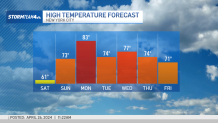
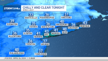
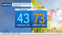
Saturday
begins
like
every
other
day
this
week:
chilly.
There
aren’t
any
frost
advisories,
but
morning
temperatures
will
be
near
freezing
for
many.
If
you
are
planning
on
an
early
morning
run,
bundle
up.
Thankfully,
a
calm
wind
means
no
wind
chill,
so
dress
for
the
number
on
the
thermometer.
Unfortunately,
that
number
will
be
in
the
30s
and
40s.
Temperatures
hit
the
upper
50s
to
low
60s
by
the
afternoon. The
winds
pick
up
and
clouds
build
late
in
the
day,
too,
ahead
of
a
warm
front
that
will
move
in
overnight.
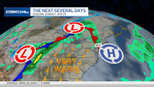
The
warm
front
will
bring
showers,
but
not
until
Saturday
evening.
If
you’ve
got
a
sporting
event
to
attend
in
the
afternoon,
you
won’t
need
an
umbrella.
But
you
will
need
a
jacket.
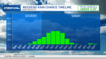
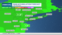
The
best
chance
for
rain
will
be
overnight
Saturday
night.
It
will
be
low-impact,
but
if
you’re
going
to
be
out
late,
think
about
carrying
an
umbrella
just
to
be
safe.
Showers
could
linger
into
Sunday
morning.
Overall
rain
amounts
will
be
under
a
half
inch
–
with
most
areas
picking
up
a
tenth
of
an
inch
or
so.
Sunday
afternoon
looks
sunny
and
dry. Temperatures
climb
into
the
70s,
so
you
can
trade
Saturday’s
jacket
for
a
t-shirt.
Sunday
will
be
just
the
start
of
a
week’s
worth
of
warm
temperatures
as
we
greet
May.
So,
for
all
of
you
who
have
been
anxious
for
it
to
feel
like
spring
outside,
next
week
is
your
payoff
for
being
patient!